
Portal:Andes
The Andes Portal

The Andes (/ˈændiːz/ AN-deez), Andes Mountains or Andean Mountain Range (Spanish: Cordillera de los Andes; Quechua: Anti) are the longest continental mountain range in the world, forming a continuous highland along the western edge of South America. The range is 8,900 km (5,530 mi) long and 200 to 700 km (124 to 435 mi) wide (widest between 18°S and 20°S latitude) and has an average height of about 4,000 m (13,123 ft). The Andes extend from South to North through seven South American countries.: Argentina, Chile, Bolivia, Peru, Ecuador, Colombia and western Venezuela.
Along their length, the Andes are split into several ranges, separated by intermediate depressions. The Andes are the location of several high plateaus—some of which host major cities such as Quito, Bogotá, Cali, Arequipa, Medellín, Bucaramanga, Sucre, Mérida, El Alto and La Paz. The Altiplano Plateau is the world's second-highest after the Tibetan Plateau. These ranges are in turn grouped into three major divisions based on climate: the Tropical Andes, the Dry Andes, and the Wet Andes.
The Andes Mountains are the highest mountain range outside Asia. The highest mountain outside Asia, Argentina's Aconcagua, rises to an elevation of about 6,961 m (22,838 ft) above sea level. The peak of Chimborazo in the Ecuadorian Andes is farther from the Earth's center than any other location on the Earth's surface, due to the equatorial bulge resulting from the Earth's rotation. The world's highest volcanoes are in the Andes, including Ojos del Salado on the Chile-Argentina border, which rises to 6,893 m (22,615 ft). (Full article...)
Selected articles
-

Chumpe (possibly from chumpi Jaqaru for corn with yellow seeds and Quechua for belt; or ch'umpi Jaqaru for red and Quechua for brown), is a mountain in the north of the Pariacaca mountain range in the Andes of Peru, about 5,200 metres (17,060 ft) high. It is situated in the Junín Region, Yauli Province, in the districts of Huay-Huay and Yauli District. Chumpe lies east of Lake Pumacocha. The mining town of San Cristóbal is situated at its feet. (Full article...) -
Acamarachi (also known as Pili) is a 6,046-metre (19,836 ft) high volcano in northern Chile. In this part of Chile, it is the highest volcano. Its name means "black moon". It is a volcano in the Central Volcanic Zone of the Andes, a zone of strong volcanic activity during the last million years. Old volcanoes in the area are well-preserved, due to the dry climate.
Acamarachi itself is a cone-shaped volcano with steep upper flanks and a lava dome on its northern side. While there is no indication of historical activity and the flank lava flows are old, some lava flows around the summit crater and a lava coulee north of Acamarachi on the saddle between Acamarachi and Colachi volcano may be postglacial in age. Acamarachi is formed by andesitic and dacitic rocks. (Full article...) -

Lake Junin (IPA: [xuˈnin]; Spanish Lago Junín, named after the nearby town of Junin) or Chinchaycocha (possibly from Quechua chincha, chinchay north, northern, chinchay ocelot, qucha lake, lagoon, "northern lake" or "ocelot lake") is the largest lake entirely within Peruvian territory. Even though Lake Titicaca has a much larger area, its eastern half is located on Bolivian territory. Lake Junin is an important birdwatching destination in the country. (Full article...) -
Volcán Marmolejo is a 6,108 m (20,039 ft) high Pleistocene stratovolcano in the Andes on the border between Argentina and Chile. It is located 9 km (6 mi) NNE of the active San José volcano, and is the southernmost 6,000 m (19,685 ft)-plus peak in the world. The Argentine portion is within the Argentinean protection area of Provincial Reserve for Multiple Use and Natural Recreation Manzano / Portillo de Piuquenes. It is on the border of two provinces: Argentinean province of Mendoza and Chilean province of Cordillera. Its slopes are within the administrative boundaries of the two cities: Argentinean city of Tunuyán and the Chilean commune of San José de Maipo. (Full article...) -
Misti is a dormant volcano located in the Andes mountains in southern Peru, rising above Peru's second-largest city, Arequipa. It is a conical volcano with two nested summit craters, the inner one of which contains a volcanic plug or lava dome with active fumaroles. The summit of the volcano lies on the margin of the outer crater and is 5,822 metres (19,101 ft) above sea level. Snow falls on the summit during the wet season, but does not persist; there are no glaciers. The upper slopes of the volcano are barren, while the lower slopes are covered by bushland.
The volcano developed over four different stages. During each stage, lava flows and lava domes built up a mountain, whose summit then collapsed to form a caldera. The volcano is part of a volcano group with Chachani to the northwest and Pichu Pichu to the southeast, and developed on top of a basement formed by numerous Miocene-Pliocene ignimbrites and volcano-derived debris. Numerous intense explosive eruptions took place during the last 50,000 years and covered the surrounding terrain with tephra. The last two significant eruptions were 2,000 years ago and in 1440–1470 AD; since then, phases of increased fumarolic activity have sometimes been mistaken for eruptions. (Full article...) -
Cotopaxi (Spanish pronunciation: [kotoˈpaksi]) is an active stratovolcano in the Andes Mountains, located near Latacunga city of Cotopaxi Province, about 50 km (31 mi) south of Quito, and 31 km (19 mi) northeast of the city of Latacunga, Ecuador. It is the second highest summit in Ecuador, reaching a height of 5,897 m (19,347 ft). Cotopaxi is among the highest active volcanoes in the world.
Cotopaxi is known to have erupted 87 times, resulting in the creation of numerous valleys formed by lahars (mudflows) around the volcano. An ongoing eruption began on 21 October 2022. (Full article...) -
Illimani (Aymara and Spanish pronunciation: [iʎiˈmani]) is the highest mountain in the Cordillera Real (part of the Cordillera Oriental, a subrange of the Andes) of western Bolivia. It lies near the cities of El Alto and La Paz at the eastern edge of the Altiplano. It is the second highest peak in Bolivia, after Nevado Sajama, and the eighteenth highest peak in South America. The snow line lies at about 4,570 metres (15,000 ft) above sea level, and glaciers are found on the northern face at 4,983 m (16,350 ft). The mountain has four main peaks; the highest is the south summit, Nevado Illimani, which is a popular ascent for mountain climbers.
Geologically, Illimani is composed primarily of granodiorite, intruded during the Cenozoic era into the sedimentary rock, which forms the bulk of the Cordillera Real. (Full article...) -
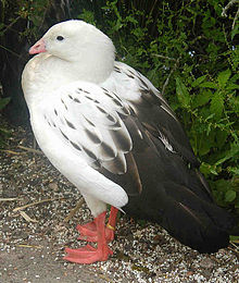
The Andean goose (Chloephaga melanoptera) is a species of waterfowl in tribe Tadornini of subfamily Anserinae. It is found in Argentina, Bolivia, Chile, and Peru. (Full article...) -
The vicuña (Lama vicugna) or vicuna (both /vɪˈkuːnjə/, very rarely spelled vicugna, its former genus name) is one of the two wild South American camelids, which live in the high alpine areas of the Andes, the other being the guanaco, which lives at lower elevations. Vicuñas are relatives of the llama, and are now believed to be the wild ancestor of domesticated alpacas, which are raised for their coats. Vicuñas produce small amounts of extremely fine wool, which is very expensive because the animal can only be shorn every three years and has to be caught from the wild. When knitted together, the product of the vicuña's wool is very soft and warm. The Inca valued vicuñas highly for their wool, and it was against the law for anyone but royalty to wear vicuña garments; today, the vicuña is the national animal of Peru and appears on the Peruvian coat of arms.
Both under the rule of the Inca and today, vicuñas have been protected by law, but they were heavily hunted in the intervening period. At the time they were declared endangered in 1974, only about 6,000 animals were left. Today, the vicuña population has recovered to about 350,000, and although conservation organizations have reduced its level of threat classification, they still call for active conservation programs to protect populations from poaching, habitat loss, and other threats. (Full article...) -
Orestias is a genus of pupfish. Older systematics classified them into the own family Orestiidae. They are found in lakes, rivers and springs in the Andean highlands of South America, and several species are considered threatened. They are egg-laying fish that feed on small animals and plant matter. The largest species can reach a total length of 27 cm (10.6 in), but most remain far smaller. Their most characteristic feature is the absence of the ventral fin, although this is shared by a few other pupfish. Despite their moderate to small size, they are important to local fisheries and a few species are farmed.
Several species are locally and colloquially known as carache. The name of the genus is a reference to Orestes, a Greek mythological character who Valenciennes described as the "nymph of the mountains". (Full article...) -
Aconcagua (Spanish pronunciation: [akoŋˈkaɣwa]) is a mountain in the Principal Cordillera of the Andes mountain range, in Mendoza Province, Argentina. It is the highest mountain in the Americas, the highest outside Asia, and the highest in both the Western Hemisphere and the Southern Hemisphere with a summit elevation of 6,961 metres (22,838 ft). It lies 112 kilometres (70 miles) northwest of the provincial capital, the city of Mendoza, about five kilometres (three miles) from San Juan Province, and 15 km (9 mi) from Argentina's border with Chile. The mountain is one of the Seven Summits of the seven continents.
Aconcagua is bounded by the Valle de las Vacas to the north and east and the Valle de los Horcones Inferior to the west and south. The mountain and its surroundings are part of the Aconcagua Provincial Park. The mountain has a number of glaciers. The largest glacier is the Ventisquero Horcones Inferior at about 10 km (6 mi) long, which descends from the south face to about 3,600 m (11,800 ft) in elevation near the Confluencia camp.
Two other large glacier systems are the Ventisquero de las Vacas Sur and Glaciar Este/Ventisquero Relinchos system at about 5 km (3 mi) long. The best known is the northeastern or Polish Glacier, as it is a common route of ascent. (Full article...) -
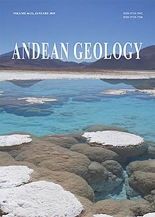
Andean Geology (formerly Revista Geológica de Chile) is a peer-reviewed scientific journal published three times per year by the National Geology and Mining Service, Chile's geology and mining agency. The journal covers the field of geology and related earth sciences, primarily on issues that are relevant to South America, Central America, and Antarctica with a particular focus on the Andes. The journal was established in 1974 and articles are published in English and Spanish. The editor-in-chief is Waldo Vivallo (National Geology and Mining Service). (Full article...) -
Cerro Escorial is a stratovolcano at the border of Argentina and Chile. It is part of the Corrida de Cori volcanic group and its youngest member. A well-preserved 1-kilometre-wide (0.6 mi) crater forms its summit area. Lava flows are found on the Chilean and smaller ones on the Argentinian side, the former reaching as far as 3–4 kilometres (1.9–2.5 mi) from the volcano. One of these is dated 342,000 years ago by argon-argon dating.
Off the western coast of South America, the Nazca Plate subducts beneath the South America Plate. This process has given rise to the Andes mountain chain and the Altiplano-Puna high plateau, which formed through shortening of the crust that lasted until 1 million years ago. Cerro Escorial rises from the Puna, which is dissected at Cerro Escorial by the Archibarca lineament; it is a strike-slip fault that has facilitated the ascent of magma. (Full article...) -
Jirishanca is a 6,094-metre-high (19,993 ft) mountain in the Huayhuash mountain range in west central Peru, part of the Andes. Other sources cite a height of 6,125 metres (20,095 ft). It is the tenth highest peak in Peru and the third in the Huayhuash range (after Yerupajá and Siula Grande). Jirishanca translates as "hummingbird bill peak". (Full article...) -
The Wet Andes (Spanish: Andes húmedos) is a climatic and glaciological subregion of the Andes. Together with the Dry Andes it is one of the two subregions of the Argentine and Chilean Andes. The Wet Andes runs from a latitude of 35°S to Cape Horn at 56°S. According to Luis Lliboutry the Wet Andes can be classified after the absence of penitentes. In Argentina well developed penitentes are found as south as on Lanín Volcano (40°S). Another difference is that the Wet Andes is largely devoid of rock glaciers. The glaciers of the Wet Andes have a far more stable line of equilibrium than those of the Dry Andes due to summer precipitations, low thermal oscillations and an overall high moisture. (Full article...) -

The royal cinclodes (Cinclodes aricomae) is a Critically Endangered passerine bird in the Furnariinae subfamily of the ovenbird family Furnariidae. It is found in Bolivia and Peru. (Full article...) -
Nevado del Huila (/nɛˈvɑːdoʊ dɛl ˈwiːlə/, Spanish pronunciation: [neˈβaðo ðel ˈwila]) at 5,364 metres (17,598 ft), is the highest volcano in Colombia, located at the tripoint of the departments of Huila, Tolima and Cauca. It is visible from the city of Cali. The andesitic volcano is located on top of the Ibagué Batholith.
After being dormant for more than 500 years, the volcano showed heavy signs of activity in 2007 and 2008. As of February 20, 2007, there were more than 7000 "minor" seismic events, and a high state of alert was in place for the departments of Cauca, Huila, Caldas and Valle del Cauca. The volcano erupted twice in April 2007, once in April 2008 and again in November 2008. Any eruption would affect the small villages around the volcano, mostly Páez, where their inhabitants still have in memory the eruption of the Nevado del Ruiz volcano and the destruction of Armero. (Full article...) -
Cerro del Nacimiento is an Andean volcano of the Cordillera de la Ramada range, in the Catamarca Province of Argentina. Its summit is 6,436 metres (21,115 ft) above sea level. (Full article...) -
Cumbal is a stratovolcano of the Caribe Terrane, located at the Nudo de los Pastos in Nariño, Colombia. It is the southernmost historically active volcano of Colombia and is together with Chiles and Azufral one of the few volcanoes of the Western Ranges. The volcano is dominated by andesites. (Full article...) -
Pico Bolívar is the highest mountain in Venezuela, at 4,978 metres (16,332 ft). Located in Mérida State. It can be reached only by walking; the Mérida cable car, which was the highest and longest cable car in the world when it was built, only reaches Pico Espejo. From there it is possible to climb to Pico Bolívar. The peak is named after the Venezuelan independence hero Simón Bolívar.
The Pico Bolívar is located on the mountain previously called La Columna, next to El León (4,743 m) and El Toro (4,695 m). The new name was suggested by Tulio Febres Cordero in 1925. It was officially renamed on December 30, 1934. (Full article...) -
Cerro Negro de Mayasquer is a volcano on the border of Colombia and Ecuador. It lies 3 kilometres (2 mi) north-west of the volcano Chiles, and the two peaks are considered part of the same Chiles-Cerro Negro volcanic complex. These volcanoes, together with Cumbal are andesitic in rock type. A 1936 eruption reported by the Colombian government agency INGEOMINAS may have been from the Ecuadorean volcano Reventador, otherwise the volcano has not erupted for around 160,000 years. (Full article...)
-
Cerro Bonete is a mountain in the north of the province of La Rioja, Argentina, near the provincial border with Catamarca. Its summit is 6,759 m above mean sea level, making it the fifth-highest separate mountain in the Americas (after Aconcagua, Ojos del Salado, Monte Pissis, and Huascaran). SRTM data disproves the frequently-made claim that its summit is 6,872 m above sea level.
Within the last 3.5 million years, volcanic activity at Cerro Bonete has formed lava domes of dacite and rhyodacite. (Full article...) -
Illimani is a mountain in the Khari Khari mountain range of the Bolivian Andes, about 5,030 m (16,503 ft) high. It is situated south-east of Potosí in the Potosí Department, Tomás Frías Province, Potosí Municipality. Illimani lies south-west of the mountain Uma Jalanta, north-east of Challwiri Lake and north of Illimani Lake. (Full article...)
-
The Sierra de La Culata is a mountain range in the largest massif in Venezuela, the Cordillera de Mérida, which in turn is part of the northern extent of the Cordillera de los Andes (Andes Mountains). The Sierra la Culata includes some of the highest peaks in Venezuela, such as Pico Piedras Blancas, Pico Pan de Azúcar, and Collado del Cóndor.
It is located between the states of Mérida and Trujillo. Most of the lagoons are a result of the Mérida glaciation. (Full article...) -
Galeras (Urcunina among the 16th-century indigenous people) is an Andean stratovolcano in the Colombian department of Nariño, near the departmental capital Pasto. Its summit rises 4,276 metres (14,029 ft) above sea level. It has erupted frequently since the Spanish conquest, with its first historical eruption being recorded on December 7, 1580. A 1993 eruption killed nine people, including six scientists who had descended into the volcano's crater to sample gases and take gravity measurements in an attempt to be able to predict future eruptions. It is currently the most active volcano in Colombia. (Full article...)


.jpg)


.jpg)


Did you know...
- ... that the 1930s Polish Andean expeditions have been credited with several first ascents and the tracing of a new route to the summit of Aconcagua, the Andes' highest peak?
Need help?
Do you have a question about Andes that you can't find the answer to?
Consider asking it at the Wikipedia reference desk.
General images
-
 The seaward tilting of the sedimentary strata of Salto del Fraile Formation in Peru was caused by the Andean orogeny. (from Andean orogeny)
 -

-

-
 Syncline next to Nordenskjöld Lake in Torres del Paine National Park. The syncline formed during the Andean orogeny. (from Andean orogeny)
 -

-
 Ulluco: Common crop of the Andean region (from Andean agriculture)
 -
 Topographic map of the Andes by the NASA. The southern and northern ends of the Andes are not shown. The Bolivian Orocline is visible as a bend in the coastline and the Andes lower half of the map. (from Andean orogeny)
 -
 Simplified sketch of the present-situation along most of the Andes (from Andean orogeny)
 -
 Parinacota, Bolivia/Chile (from Andes)
 -
 Frederic Edwin Church, Heart of the Andes, 1859. (from Andes)
 -
 Peruvian farmers sowing maize and beans (from Andes)
 -
 Aerial view of Valle Carbajal in the Tierra del Fuego. The Andes range is about 200 km (124 mi) wide throughout its length, except in the Bolivian flexure where it is about 640 kilometres (398 mi) wide. (from Andes)
 -
 View of Cuernos del Paine in Torres del Paine National Park, Chile (from Andes)
 -

-
 Nevado del Huila, Colombia (from Andes)
 -

-
 Bolivian Andes (from Andes)
 -
 Laguna de Sonso tropical dry forest in Northern Andes (from Andes)
 -
 Paleogeography of the Late Cretaceous South America. Areas subject to the Andean orogeny are shown in light grey while the stable cratons are shown as grey squares. The sedimentary formations of Los Alamitos and La Colonia that formed in the Late Cretaceous are indicated. (from Andean orogeny)
 -
 Pico Humboldt at sunset (from Andes)
 -

-
 Irrigating land in the Peruvian Andes (from Andes)
 -
 Pacha Mama Ceremony (from Andean agriculture)
 -
 A male Andean cock-of-the-rock, a species found in humid Andean forests and the national bird of Peru (from Andes)
 -
 Central Andes (from Andes)
 -

-

-
 Map of a north-south sea-parallel pattern of rock ages in western Colombia. This pattern is a result of the Andean orogeny. (from Andean orogeny)
 -
 Mashua tubers (from Andean agriculture)
 -
 Map of the Andean region of South America (from Andean agriculture)
 -

-

-


.jpg)


.jpg)


%E2%80%93Valle_Carbajal_01.jpg)


.JPG)


.jpg)

Subcategories

- Select [►] to view subcategories
Related portals
Subtopics
Associated Wikimedia
The following Wikimedia Foundation sister projects provide more on this subject:
-
 Commons
Free media repository -
 Wikibooks
Free textbooks and manuals -
 Wikidata
Free knowledge base -
 Wikinews
Free-content news -
 Wikiquote
Collection of quotations -
 Wikisource
Free-content library -
 Wikiversity
Free learning tools -
 Wiktionary
Dictionary and thesaurus


