Portal:Pennsylvania
The Pennsylvania Portal Pennsylvania (/ˌpɛnsɪlˈveɪniə/ , lit. 'Penn's forest country'), officially the Commonwealth of Pennsylvania (Pennsylvania Dutch: Pennsylvanie), is a state spanning the Mid-Atlantic, Northeastern, Appalachian, and Great Lakes regions of the United States. Pennsylvania borders Delaware to its southeast, Maryland to its south, West Virginia to its southwest, Ohio and the Ohio River to its west, Lake Erie and New York to its north, the Delaware River and New Jersey to its east, and the Canadian province of Ontario to its northwest. Pennsylvania was founded in 1681 through a royal land grant to William Penn, the son of the state's namesake. Prior to that, between 1638 and 1655, a southeast portion of the state was part of New Sweden, a Swedish Empire colony. Established as a haven for religious and political tolerance, the colonial-era Province of Pennsylvania was known for its relatively peaceful relations with native tribes, innovative government system, and religious pluralism. Pennsylvania played a vital and historic role in the American Revolution and the ultimately successful quest for independence from the British Empire, hosting the First and Second Continental Congress, leading to the adoption of the Declaration of Independence and the formation of the Continental Army. On December 12, 1787, Pennsylvania became the second state to ratify the U.S. Constitution. The bloodiest battle of the American Civil War, at Gettysburg over three days in July 1863, proved the war's turning point, leading to the Union's preservation. Throughout the late 19th and 20th centuries, the state's manufacturing-based economy contributed to the development of much of the nation's early infrastructure, including key bridges, skyscrapers, and military hardware used in U.S.-led victories in World War I, World War II, and the Cold War. Pennsylvania's geography is highly diverse. The Appalachian Mountains run through the center of the state; the Allegheny and Pocono mountains span much of Northeastern Pennsylvania; close to 60% of the state is forested. While it has only 140 miles (225 km) of waterfront along Lake Erie and the Delaware River, Pennsylvania has the most navigable rivers of any state in the nation, including the Allegheny, Delaware, Genesee, Ohio, Schuylkill, Susquehanna, and others. (Full article...) This is a Featured article, which represents some of the best content on English Wikipedia..
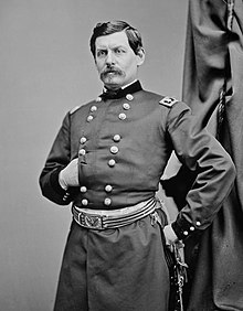
George Brinton McClellan (December 3, 1826 – October 29, 1885) was an American military officer and politician who served as the 24th governor of New Jersey and as Commanding General of the United States Army from November 1861 to March 1862. He was also an engineer, and was chief engineer and vice president of the Illinois Central Railroad, and later president of the Ohio and Mississippi Railroad in 1860. A West Point graduate, McClellan served with distinction during the Mexican–American War before leaving the United States Army to serve as a railway executive and engineer until the outbreak of the American Civil War in 1861. Early in the conflict, McClellan was appointed to the rank of major general and played an important role in raising the Army of the Potomac, which served in the Eastern Theater. (Full article...)Selected geography article -
Pennsylvania Route 463 (PA 463) is a 12.9-mile-long (20.8 km) state highway completely in Montgomery County, Pennsylvania. Its western terminus is at PA 63 in Hatfield Township and its eastern terminus is at PA 611 in Horsham. PA 463 runs through the northern suburbs of Philadelphia and passes through the towns of Hatfield, Montgomeryville, and Horsham. The route intersects PA 309, U.S. Route 202 Business (US 202 Bus.), and US 202 in Montgomeryville and PA 152 in Prospectville. Through its length, the route carries the names Forty Foot Road, Broad Street, Main Street, Cowpath Road, and Horsham Road. PA 463 was designated in 1928 and fully paved by 1940. In 2010, a portion of the route in Montgomery Township was widened. (Full article...)
Selected image -Did you know -
Related portalsWikiprojectsThis is a Good article, an article that meets a core set of high editorial standards.
The Battle of Jumonville Glen, also known as the Jumonville affair, was the opening battle of the French and Indian War, fought on May 28, 1754, near present-day Hopwood and Uniontown in Fayette County, Pennsylvania. A company of provincial troops from Virginia under the command of Lieutenant Colonel George Washington, and a small number of Mingo warriors led by the chieftain Tanacharison (also known as the "Half King"), ambushed a force of 35 French Canadians under the command of Joseph Coulon de Jumonville. A larger French Canadian force had driven off a small crew attempting to construct Fort Prince George under the auspices of the Ohio Company at present-day Pittsburgh, Pennsylvania, land claimed by the French. A British colonial force led by George Washington was sent to protect the fort under construction. The French Canadians sent Jumonville to warn Washington about encroaching on French-claimed territory. Washington was alerted to Jumonville's presence by Tanacharison, and they joined forces to ambush the French Canadian camp. Washington's force killed Jumonville and some of his men in the ambush and captured most of the others. The exact circumstances of Jumonville's death are a subject of historical controversy and debate. (Full article...)Selected article - The history of Pennsylvania stems back thousands of years when the first indigenous peoples occupied the area of what is now Pennsylvania. In 1681, Pennsylvania became an English colony when William Penn received a royal deed from King Charles II of England. Although European activity in the region precedes that date (the area was first colonized by the Dutch in 1643). The area was home to the Lenape, Susquehannocks, Iroquois, Erie, Shawnee, Arandiqiouia, and other American Indian tribes. Most of these tribes were driven off or reduced to remnants as a result of diseases, such as smallpox. The English took control of the colony in 1667. In 1681, William Penn, a Quaker, established a colony based on religious tolerance; it was settled by many Quakers along with its Philadelphia, its largest city, which was also the first planned city. In the mid-1700s, the colony attracted many German and Scots-Irish immigrants. (Full article...)Pennsylvania news
CategoriesState factsState Facts
State symbols
Pennsylvania topicsGeneral imagesThe following are images from various Pennsylvania-related articles on Wikipedia.
Associated WikimediaThe following Wikimedia Foundation sister projects provide more on this subject:
Discover Wikipedia using portals |


